The ARCH Risk Scenario Toolbox
As part of its co-creation approach, ARCH developed and adapted a set of tools and methods to support with the co-identification, co-prioritization, and co-definition of risks, impacts, and the cause-effect relationships between them. The resulting toolbox consists of a risk profiling table, a scenario prioritization tool, and a (miro) template for the creation of Impact Chains.
The three elements of the toolbox build on each other. You should first fill out the risk profiling table, then prioritize scenarios using the prioritization tool, and finally create Impact Chains for the highest rated risk scenarios. Hoewever, if you already have sufficient information on the potential risks and impacts in your historic area, have decided on the most pressing risks to adress, or are already clear on the cause-effect relationships between impacts and risks, you can also use the elements of the toolbox in isolation.
The different elements of the toolbox are briefly explained below. We also provide them here as downloads for everybody, in the hope that they can support others outside the ARCH consortium. The elements of the toolbox are free to use, redistribute, and adapt.
You can find out more about the Risk Scenario Toolbox and how ARCH applied this in its co-creation activities in Deliverable D3.5.
The Risk Profiling Table
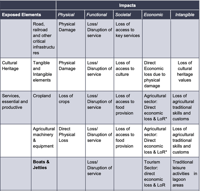
To elicit relevant information for supporting the co-creation of risk analyses ARCH developed a Risk Profile Table, guiding practitioners through the identification of two of the determinants of risks, namely hazards and exposure, as well as the identification of the possible impacts that the different dimensions of the historic area social-ecological system might face.
The risk profiling table is subdivided in three different sections, namely:
-
- Hazards;
- Elements exposed to different hazards; and
- Impacts induced by the different identified hazards on the different identified exposed elements.
It is helpful to provide a list of possible descriptors for the hazards, exposed elements, and impacts (encompassing the different dimension of the historic areas, i.e. physical, societal, functional, economic, and intangible impacts) to support the risk profiling exercise.
You can download the excel template below.

The Risk Scenario Prioritization Tool
In order to identify the most pressing risk scenarios that should be analysed in more detail, ARCH developed the risk scenario prioritization tool. This is a simple Excel-based spreadsheet, structured as a matrix as follows:
-
- First column (light blue area ) includes the name of the hazards identified after filling out the hazard module of the risk profiling table;
- Top rows: includes the list of the:
- First top row (in grey) dimensions identified for the social-ecological-system of the historic areas, namely: built-environment; natural-environment; economic dimension; social dimension; cultural dimension (both tangible & intangible); and political dimension;
- Second top row (in yellow) sub-dimensions identified and deemed peculiar for each one of the social-ecological system dimension, corresponding to the exposed elements identified in the exposure module of the risk profiling table.
The Risk Scenario Prioritization Tool can be used to score the identified potential risks by implementing the following steps:
-
- Write the name of the selected hazards (from the ones annotated in the Risk Profiling Table, Hazard module) in the first column, blue area;
- Write in the name of the selected exposed elements (from the ones resulting from the Risk profiling Table, Exposure module) for each one of the social-ecological system dimensions; these should be written in the second tow row, yellow area;
- Self-score to the best of your knowledge the severity and extend of the impacts that each one of the hazards might induce in each one of the exposed elements (by using a five level impact scale from 1 to 5).
Once the matrix has been filled out the excel spreadsheet automatically calculates some “results” by combining and averaging the scores. The formula beyond the “results” calculation might need to be set by technical partners supporting you in the risk analysis.
You can download the Risk Scenario Prioritazation Tool below.

The Impact Chain Template
After identifying and prioritising the different risks that your histopric area faces, Impact chains can be used to identify and describe relevant cause-effect relationships as a basis for further damage and impact analysis.
Impact chains are a framework to understand, systematize and prioritize the factors that drive climate related risks in a specific system of concern. They can serve as a backbone for a risk assessment and are a useful tool for analysis as well as for communication of complex cause-effect relationships of impacts and risks. The structure of the impact chain represents the main cause effect chains: a climate signal (e.g. a heavy rain event) may lead to a sequence of intermediate impacts (e.g. erosion upstream that contributes to flooding downstream), which in interaction with the vulnerability of exposed elements of the social-ecological system finally leads to a risk (or multiple risks).
Impact chains also serve as a basis for the selection of appropriate indicators as well as a backbone for the aggregation of indicators to composite risk indicators. Risk assessments based on impact chains can combine data and model driven approaches with expert-based approaches.
The Impact chain approach makes heavy use of knowledge co-production approaches through participatory workshops in which impact chains and indicators are jointly defined between researchers, experts from municipalities, local businesses, NGOs, civil society, and other local stakeholder groups, thus validating the results and ensuring ownership and sustainability.
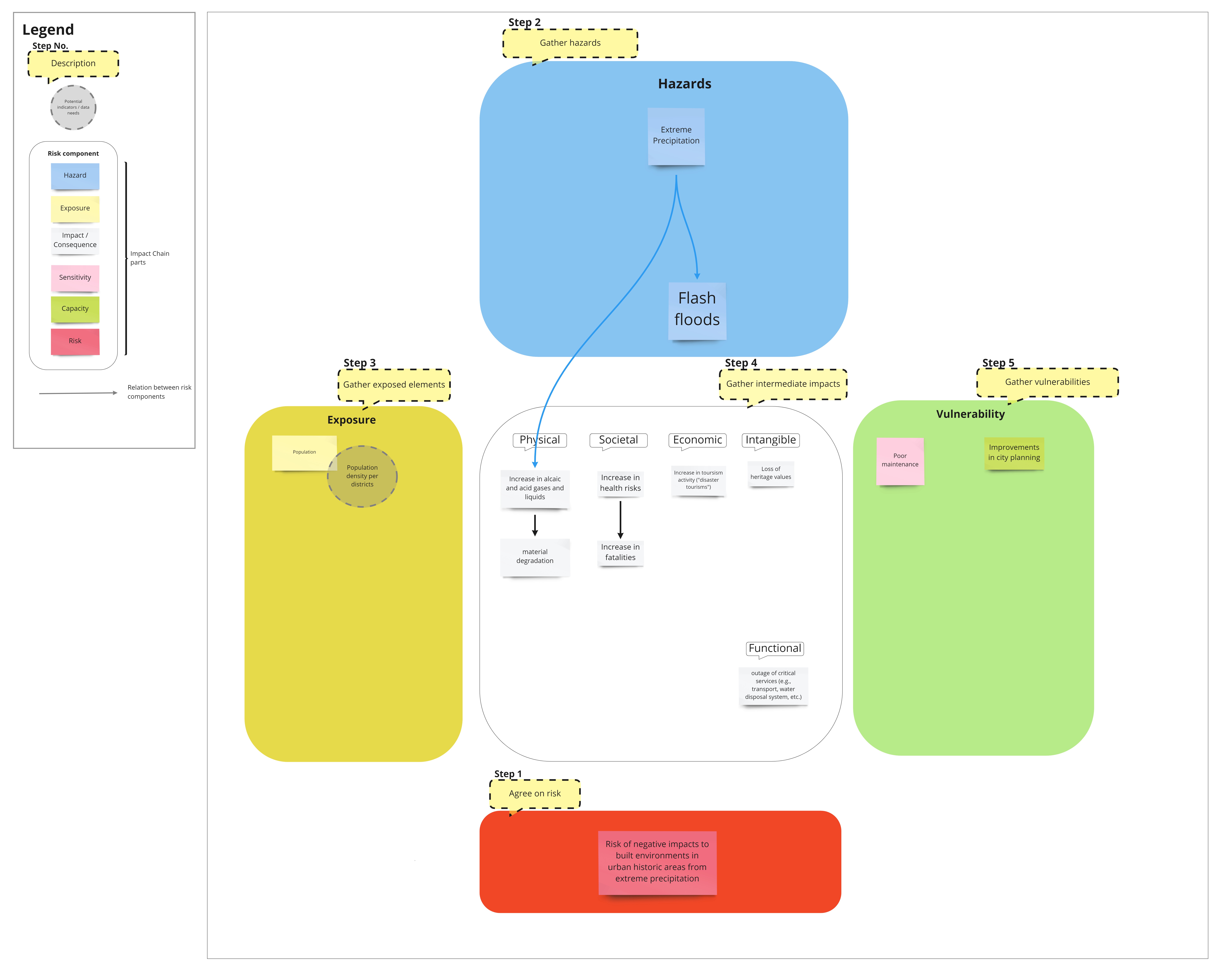
In order to support with the co-development of impact chains, ARCH created a miro template that guides you through the creation of an impact chain in five steps:
-
- Define the risk you want to analyse; be as specific and clear as possible; what is the hazard of concern? What is exposed to the hazard? What is the main impact?.
- Gather all relevant climatic hazard information; which hazards drive the risk, are they connected to other hazards?
- Identify the elements exposed to the hazards; which elements of your historic area will be impacted by the hazards you identified?
- Identify the impacts that might occur; these are the hazards and consequences that are impacted not only by the climatic hazards, but also by the vulnerabilities (sensitivity and capacity) of the system of concern. As in the risk profiling table, we distinguish between different types of impacts.
- Identify the vulnerabilities of the system; which factors make the impacts stronger? Which factors make them weaker? Link these factors to the relevant impacts.
Below you can download the impact chain template as PDF.
